
Baldwin County: The National Weather Service confirmed a brief tornado touched down west-northwest of Milledgeville just after 4 p.m. on April 5th.
More than 100 trees were reported down around a property just south of the Old Monticello Road NW and Avery Store Road intersection, with additional trees snapped or uprooted about 1/2 mile up along Avery Store Road.
A weak tornado debris signature was evident from radar as the circulation moved north-northeast.
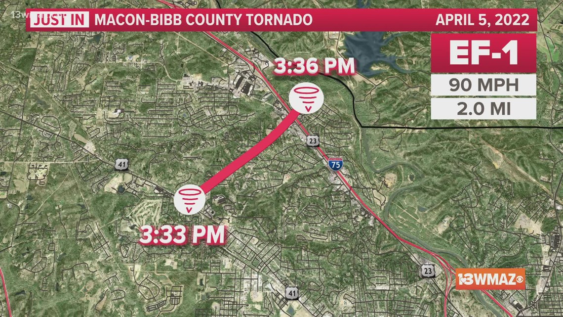
Macon/Bibb County: The tornado that struck Macon-Bibb County on Tuesday was rated at EF-1 strength, with the highest wind gusts at 90 mph.
At 3:33 p.m. Tuesday, a brief tornado touched down on the north side of Macon near Piedmont Northside Hospital.
More significant damage was quickly seen around the Wimbush Road and Old Lundy Road intersection. A church steeple was heavily damage along with multiple larger trees snapped or uprooted.
The tornado lifted minutes later at 3:36 p.m. as it was crossing Interstate 75.

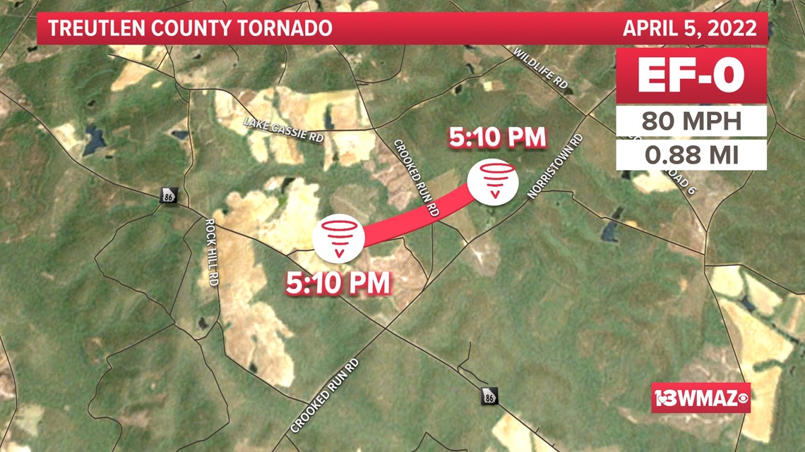
Northern Treutlen County: A brief QLCS EF0 tornado quickly evolved within the line of storms which moved through Central GA on the Tuesday afternoon.
The tornado touched down southeast of Adrian along Hidden Acres Lane where several trees were snapped and uprooted. The tornado continued NE crossing Crooked Run Road before lifting.

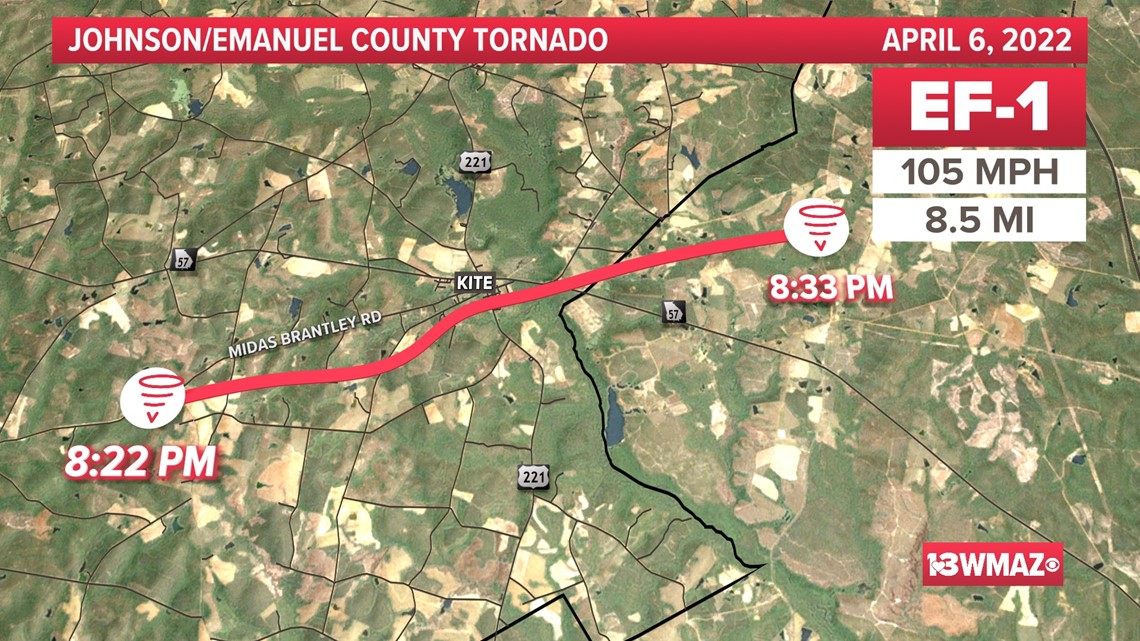
Johnson/Emanuel County: This EF-1 tornado formed at 8:22 p.m. and intensified quickly after it formed about 500 yards southwest of the intersection of Meeks Road and Midas Brantley Road.
It reached a 105 mph peak intensity as it moved east-northeast, ripping off the carport of a ranch-style brick home and tearing off one third of its roof.
As the tornado traveled east-northeast it took a slight left turn into the southwest and south portion of the city of Kite causing significant damage to about 20-30 homes, mostly roofs.
Numerous outbuildings were destroyed. Hundreds of trees were snapped or uprooted. A baseball field sustained heavy damage to the concession building, fencing and stands.
After this point the tornado weakened and downed several trees as it crossed Price William Road in Emanuel County and eventually lifted just east of Pinetucky Road at 8:33 p.m.

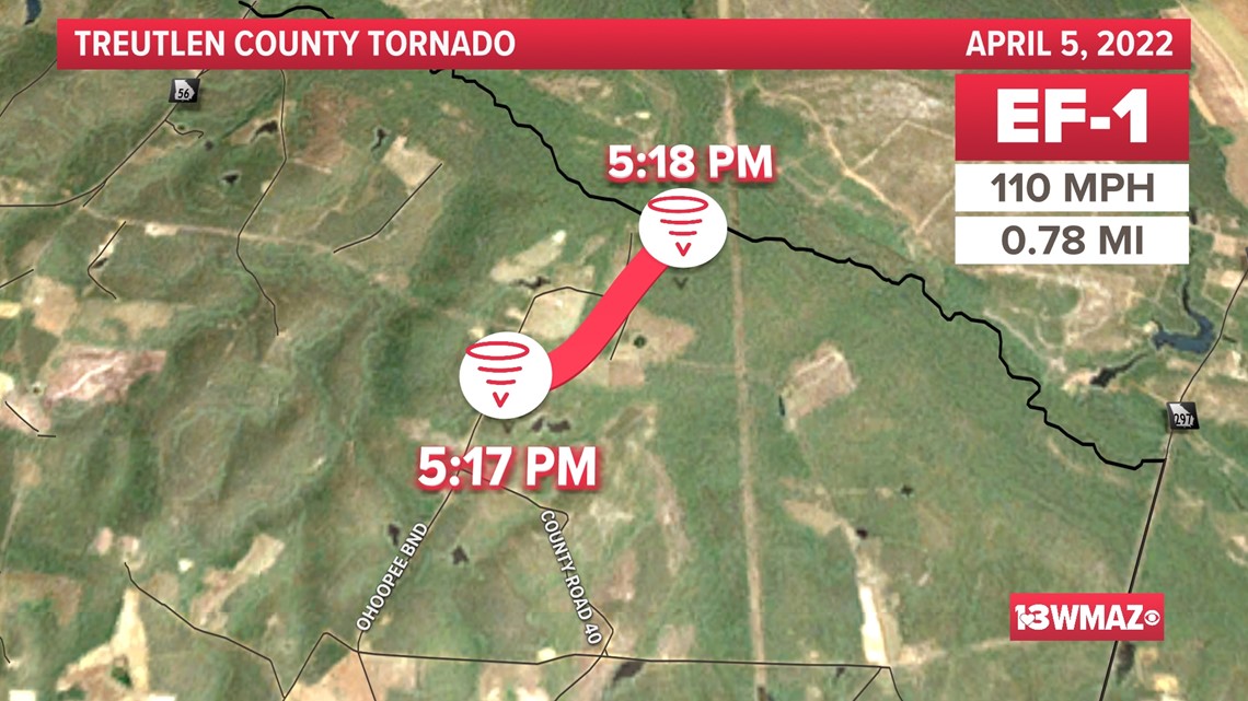
Treutlen County: A fast-moving tornado touched down at 5:17 p.m. Tuesday afternoon, south of Holton Chapel Road.
Initially, it destroyed several barns and outbuildings and heavily damaging two homes on Ohoopee Bend. A double-wide trailer home was moved off its foundation and had significant loss of siding and shingles but remained intact.
Almost all of the 100 trees in the area of the trailer were snapped or uprooted. This area received the highest maximum wind speed estimate of 110 mph.
The tornado was only on the groud for less than a mile, dissipating before cross the Ohoopee and Little Ohoopee Rivers.

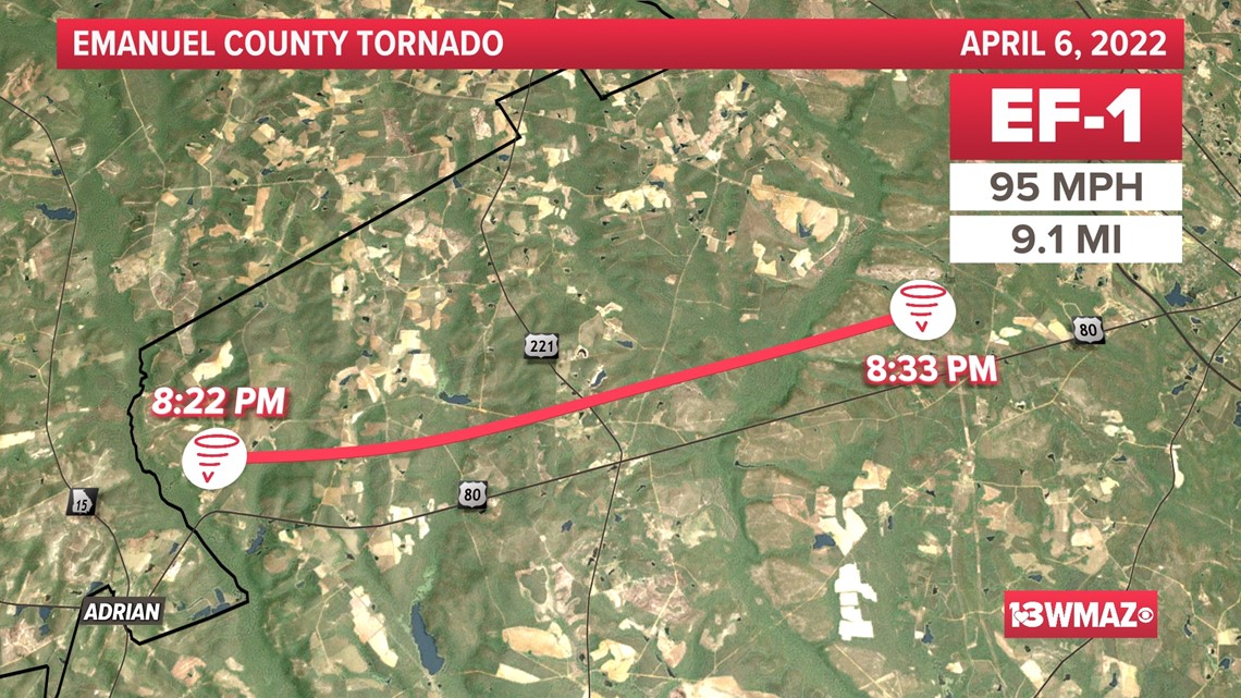
Emanuel County: On Wednesday night, a tornado touched down at 8:22 p.m., north of Adrian, trees and continued north of due-east nearly paralleling a line just north of US-80.
Along Odomville Church Rd west of US-221, numerous trees were snapped, some falling on homes. The tornado weakened some then intensified as it crossed Cow Ford Bridge Rd snapping or uprooting 50-100 trees over a nearly half mile wide swath.
The tornado weakened again as it traveled into rural areas north of US-80. It lifted at 8:33 p.m., about 4 miles west of Swainsboro.

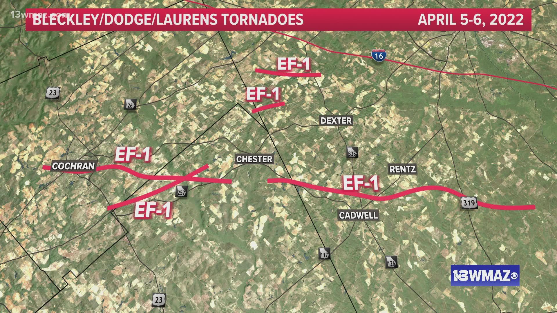
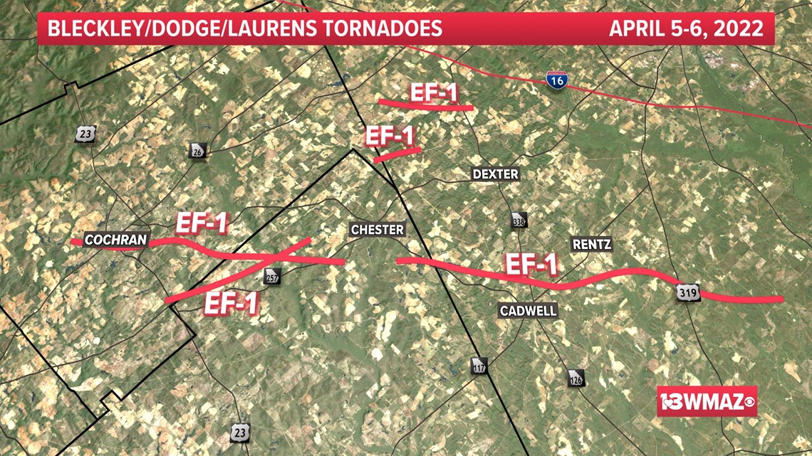
Bleckley/Dodge/Laurens Counties: The National Weather Service has confirmed five additional tornadoes in Bleckley, Laurens, and Dodge Counties from April 5-6, including one that struck downtown Cochran. All five have been rated EF-1s. More details are expected from the National Weather Service soon.

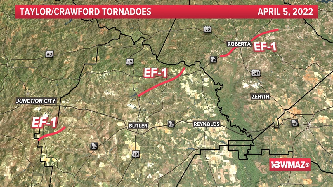
Taylor and Crawford Counties: One storm produced three separate tornadoes over the course of 50 minutes on Tuesday. The first tornado touched down near Mauk at 2:29 p.m. and traveled east, quickly intensifying to max intensity with winds of 100 mph as it crossed Highway 90. This tornado was on the ground for 3 miles.
The tornado lifted and a second touched down minutes later near the McCants Mill Pond area, along Thomaston Highway, north of Butler. It traveled for more than 7 miles with peak winds of 105 mph.
The tornado reached maximum intensity in the Fickling Mill area where large groves of trees were completely snapped and uprooted as it crossed Roberta Hwy. The EF1 tornado lifted before reaching the Crawford County line in the Pearce Road area.
Less than 10 minutes later, a third tornado touched down as it approached the town of Roberta from the southwest. Numerous trees and structures were damaged in the city of Roberta as the tornado traveled for over 9 miles, eventually lifting at 3:19 p.m.

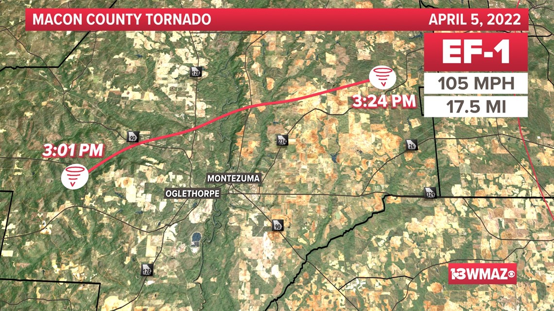
Macon County: An EF-1 tornado touched down at 3:01 p.m, just south of Ideal, in the Fountainville community. Numerous trees were snapped an minor damage occurred at the Tyson Foods plant along Highway 90.
The tornado continued northeast snapping trees before reaching Whitewater State Park, where both ground survey and radar confirm it likely reached maximum intensity with winds of 105 mph.
The tornado cross the Flint River and Highway 49 before lifting along Perkins Farm Road at 3:24 p.m. It traveled for 17.5 miles.

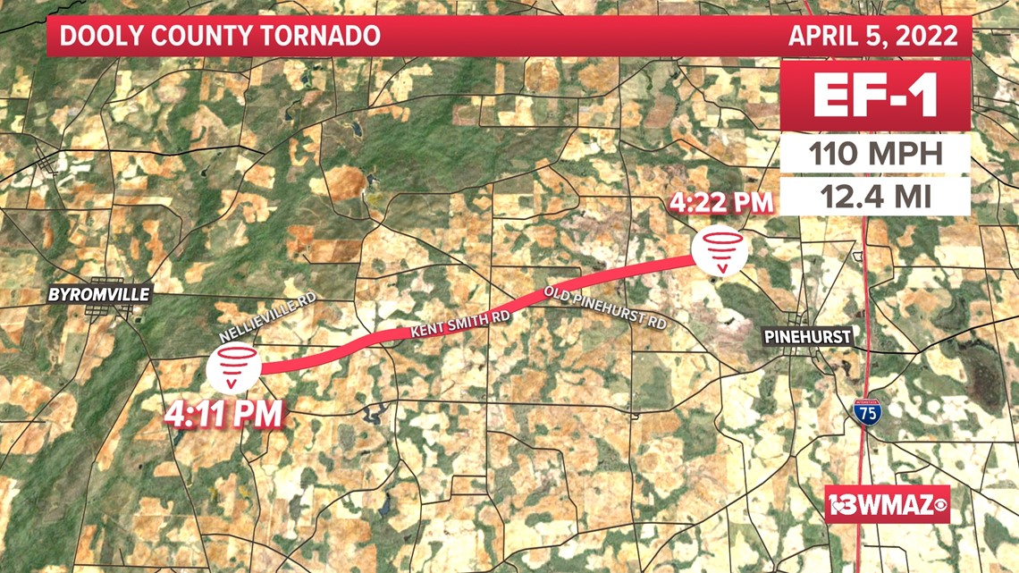
Dooly County: An EF-2 tornado struck Dooly County, near Byromville, Tuesday afternoon. The tornado touched down at 3:26 p.m. and had maximum winds of 130 mph.
According to the NWS report, the tornado rapidly developed and intensified near Pinehurst-Byromville Road and Nelleville Road east of Byromville -- destroying five large, strongly anchored grain bins.
Additionally, the weather service noted that a University of Georgia Mesonet weather station was damaged, but continued to report wind and pressure data, measuring a maximum gust of 129.3 mph.
After traveling almost 6 miles, the tornado lifted at 3:33 p.m., about 2 miles west of I-75.

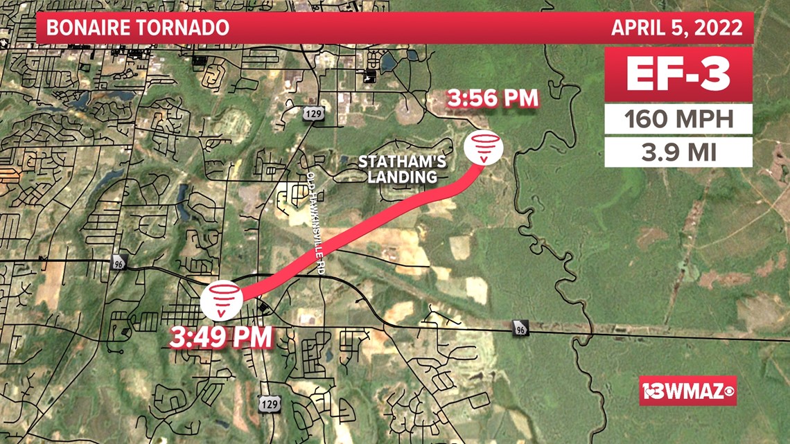
Houston County: An EF-3 tornado, with peak winds at 160 mph, struck the Bonaire community Tuesday afternoon.
The tornado touched down near Bonaire Elementary School at 3:49 p.m. and rapidly intensified.
After crossing US-129, the tornado went over an open field near the Old Hawkinsville Road and Cullen Road intersection. Two large high-tension transmission towers were destroyed and another large concrete power pole was snapped near its base.
The damage to these poles are consistent with EF-3 damage.
After causing damage to the power infrastructure, it did significant damage to multiple homes, with one completely destroyed, before entering the Statham's Landing neighborhood.
In Statham's Landing, significant damage was observed along Fairways Drive up to Fifth Fairway.
The tornado lifted after being on the ground for nearly four miles, before crossing the Ocmulgee River into Twiggs County.

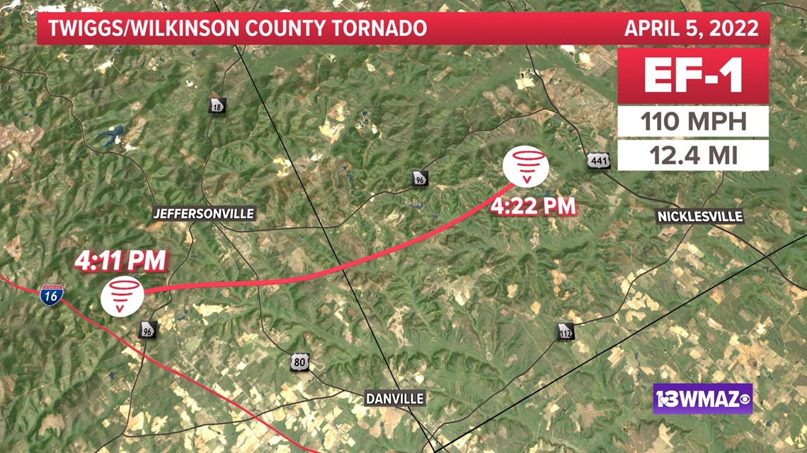
Twiggs/Wilkinson County: A high-end EF-1 tornado, with winds of 110 mph, touched down at 4:11 pm. in far eastern Twiggs County and quickly moved into Wilkinson County.
It was at its strongest along Highway 96 south of Jeffersonville and missed the radar by a mile and a half.
According to the National Weather Service, five homes were damaged including one that had a garage area collapse. Also along Highway 96, a manufactured home was pushed off its foundation with significant roof and siding damage.
The tornado missed the Jeffersonville city center by approximately 2.3 miles.
The tornado continued for 12.4 miles before lifting at 4:22 p.m.

National Weather Service crews continue to survey damage. This story will be updated as tornadoes are confirmed.